|
The Cybis program suite for dendrochronology has been extended with the capability to convert plotted ring width curves,
measured by CooRecorder, into ring width data readable by CDendro.
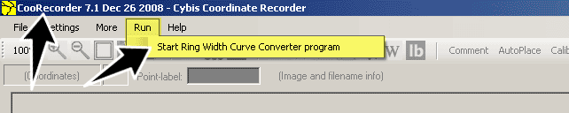
This is made possible by a program, called RWCurveConvert (Ring Width Curve Converter), which can read one or more CooRecorder coordinate files and
process them to obtain a single “.WID” file.
|
How to convert diagrams of chronology curves to readable .WID files.
A step by step description
|
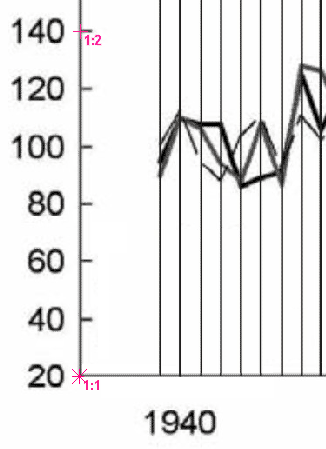
Scan the image containing the diagram, possibly at 300 dpi, and save it as a .JPG file
(or in any other CooRecorder-compatible format).
When the plotted diagram covers more than one page, scan all the images and name them in a consistent ordered way,
|
|
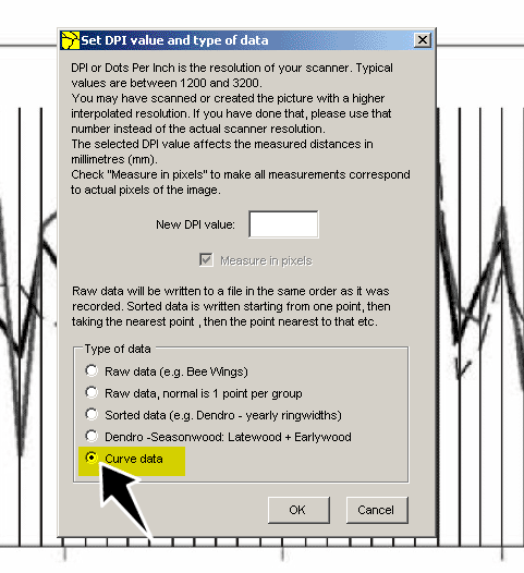
Select "Curve data" |
|
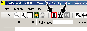
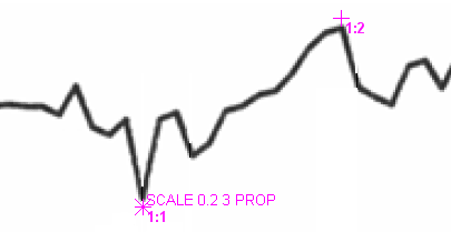
One point (normally the first) should be a "double-point" (group) with a label (point-label) specifying the vertical scaling properties of the diagram.
First we will set the double-point. To do this: Select 'More than one point per line' and 'Data picking mode'! |
|
|
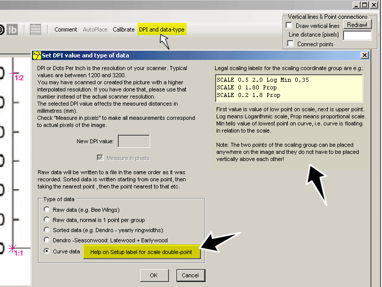
| If you again click on the "DPI and data-type" command on the menu, you will see a button "Help on Setup label for scale double-point". (This button is visible after you have selected the Curve data mode.) The button expands the window with some more information. You can copy one of the "SCALE-lines" and then paste it into the point-label textbox and then adjust it to correspond to the scaling of your curve diagram. When ready here, click OK. |
|
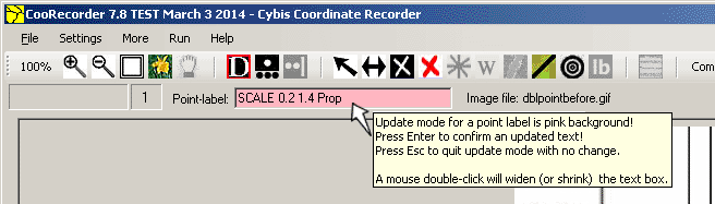
See that your doublepoint is selected.
Then click in the textbox for the Point-label and write or copy and edit the scaling information.
When ready, confirm the text by pressing Enter!
(The pink background was introduced with version 7.8 of March 3 to make the edit mode more apparent and avoid a mix-up of intended shortcut commands with text going into the label.) |
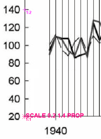
SCALE 0.2 1.4 PROPThe first word tells the program that you are actually going to specify a scale.Then you let the program know that the first point you mark will be on the "0.2" reference on the original printed scale of the diagram, while the "1.4" represents the second point you chose on the scale. Finally, the keyword “PROP” means that you are working on a diagram with a proportional/linear scale. If you are using a diagram that shows a logarithmic scale, follow the same method but replace “PROP” with “LOG”. As a third possibility, the curve may "float", i.e. there is no known zero point for the curve.
Sometimes the smallest ring width is quoted with other basic data in the published paper.
|
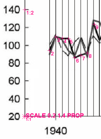
No scale available
| When there is no scale available, you have to estimate reasonable values for the smallest and the biggest ring widths of your curve, say 0.2 mm and 3 mm. You can then set your pair of SCALE-points in the vicinity of the corresponding points on the curve as shown above. |
Recording points on the curve
|
After you have marked the two-point scale, you can start to record every point of the diagram, from left to right.
The first point you record will be identified on the screen by number 2, since you have used number 1 for the scale. The second point will be number “3” and so on. If you miss a point, you may insert it when you like. You may also delete points as you like.
(The automatic sorting whenever you set a new point was introduced with version 7.8 of 3 March 2014. In previous versions the sorting was not done until you saved the file.) |
When there are no year marks
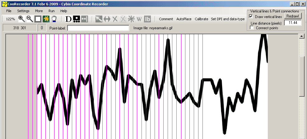
When there are no year marks at all, you may turn on the vertical help lines of CooRecorder: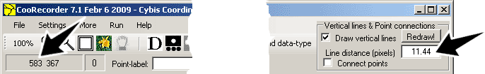
|
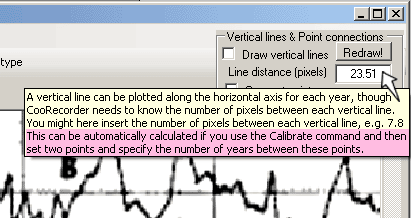
Choose two suitable points on the time scale (quite distance apart) with a known number of years in between. First put the cursor at the right point in the diagram and notice the X-coordinate value as shown above (583). Then put the cursor at the left point and get another X-coordinate value. Calculate the distance in pixels between these two points on the time scale and divide that value with the number of years in between. In this case 583 - 12 = 571 / 50 years = 11.44 pixels per year. Enter that value into the "Vertical lines textbox" as shown above - then click on the button "Redraw!" The button face now goes red to mark that CooRecorder is waiting for your action. Now click on a well defined point on the curve, i.e. a point where the curve changes its direction. Note: From version 7.8 of March 2 2014 "the distance in pixels" calculation above can be done with the Calibrate command, which now has
a special mode for the "Curve data type" mode. You then only have to set out two points and specify the number of years between them.
The result will automatically be written into the "Vertical lines textbox". After this calibration, click the "Redraw!" button
and continue as described above.
 |
|
You now have a number of vertical lines as a substitute for yearly markers - just go ahead and start recording your points on the curve!
When the vertical lines are no longer in synchronization with the curve, you can easily have them redrawn and centred around another curve point. To do this, first click on the "Redraw!" button (you may as well press the V-key on your keyboard) and then click on a suitable point on the curve. To remove the vertical lines, uncheck the box "Draw vertical lines" in the upper right corner above! |
|
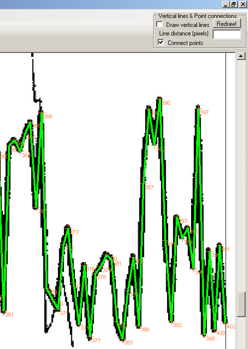
If you check the "Connect points" checkbox your points will be connected into a curve. You may check and uncheck repeatedly to see that your curve looks correct.
Also, when there are multiple curves (e.g. two) in the same diagram, you might consider to set out labels in CooRecorder at e.g. a certain year in both curves. These labels are then transfered to the .wid files and should pop up at the same year when the two curves are plotted over each other by CDendro. This facilitates the synchronization of the two curves. |
Curves spanning over more than one page
|
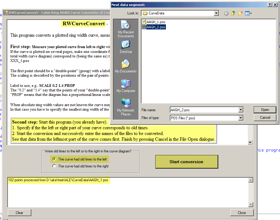
When a curve spans over several pages, you must store the data in one .pos file for each page and preferably name them, for example, AAGH_1.pos, AAGH_2.pos, AAGH_3.pos and so on.
It is important that the curves are measured from left to right,
The SCALE label must only be recorded in ONE of the images - best to always have it with the first/leftmost image!
Note: It is probably a good idea to save and/or name these coordinate files so they cannnot be mistaken for CDendro coordinate files! |
|
Start the conversion and enter successively the names of your coordinate files.
It is important that these file names are entered in their right order as when the full length curve is seen from left to right! The rightmost point of each image should correspond to (i.e. be the same as) the leftmost point of the next image. Click Cancel when all file names are entered. |
|
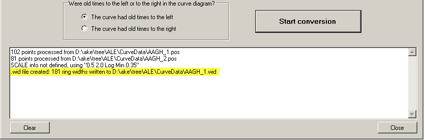
The result is stored in a .wid-file as reported above.
The file name is created from the name of the first file fed to the program, e.g. as AAGH_1.wid There will be no warning on overwriting an old file with that name! |
|
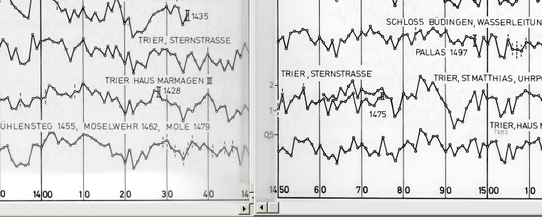
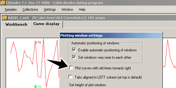
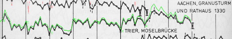
Ring width curves plotted in journals and other reports usually have old times to the left in the diagrams.
|
|
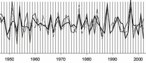
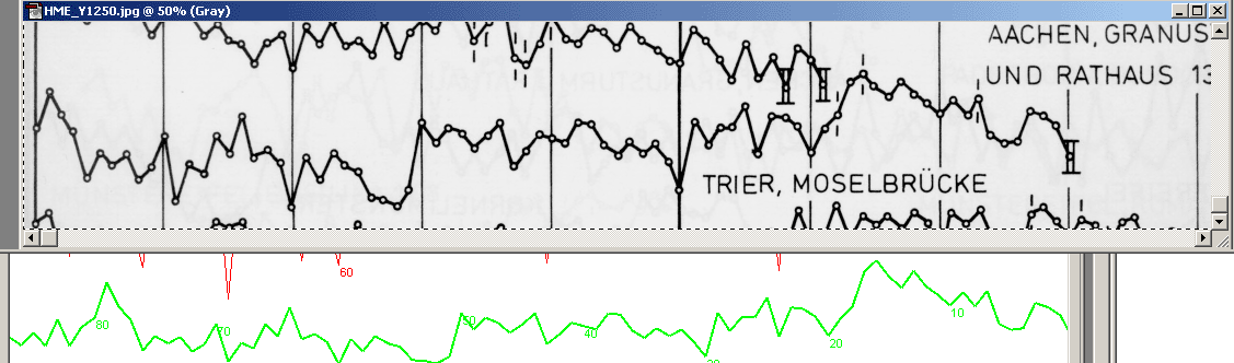
A more careful stretching of the curves will show that there is no missing ring width point in the new (green) curve in CDendro.
The difference in height of the curves comes from the scanned Hollstein curve being logarithmic while the CDendro curve is proportional.
To make a complete comparison we should also check that the oldest sections of the curves match each other.
When you are finished with the comparison, do not forget to restore the setting of the checkbox "Plot curves with old times towards right" if that has been changed. |
|
Notes:
Tip: The “Hollstein automatic measurement feature” of CooRecorder uses pattern recognition to automatically find those small circles at the nodes of the Hollstein diagrams and some other old-style diagrams. To use this feature you have to check the corresponding checkbox, which is visible when the “Enable undocumented features” checkbox is checked.(This setting is not saved, so you have to check the box every time you start the program). To make the "find" start, press the G button. Remember that the C button removes the last point train automatically created. |
|
References:
1: HOLLSTEIN E., Mitteleuropäische Eichenchronologie: Trierer dendrochronologische Forschungen zur Archäologie und Kunstgeschichte, Mainz am Rhein, 1980. 2: CREUS NOVAU, J., SAZ SÁNCHEZ, M. A., La sequía como principal factor limitante del desarrollo de pinus halepensis mill. en el sector central del Valle del Ebro, in El Clima entre el Mar y la Montaña, Santander, 2004, fig. 5. |